7 Useful GIS Tools for Water Drainage Determination

GIS Mapping and GIS Maps Uses
October 23, 2017
Remote Sensing of Environment for Water Quality Monitoring
November 1, 2017
What is Water Drainage?
The term drainage is referred to a very wide range of phenomena and situations. For example, it can describe the runoff degree of stormwater or the wastewater produced from a household or irrigation, individually or collectively. Water drainage can be completely different in an urban area from an agricultural area looking at the entire systems being developed in those two areas. We can define the water drainage system as the natural or artificial removal of a surface’s water and sub-surface water from an area.
An artificial water drainage system can be divided in:
- Surface water drainage which is the removal of excess water from the surface of the land with pipes, sewers, drains etc. given artificially a slope to end up at the right place.
- Subsurface water drainage which is the removal of water from the root zone by deep open drains which allow the excess water to flow there, or by buried pipe drains in which the water goes inside and then concludes in a collector drain.
The natural water drainage systems include reducing as much as possible pavements, gardening in sidewalks and around houses and retention tanks where the water ends up and gets stored for irrigation or other uses.
How GIS is Useful for Water Drainage
GIS depiction transparent water
GIS, as it is well known, is software with plenty of opportunities. In this case, also, it can be combined efficiently with water drainage mapping in order to visualize the data and make decisions about the study area. So what is the relation between them, we will see it below!
First of all, we need to have data on rainfall intensity, duration-frequency relationships, together with adequate data on the urban storm drainage network and catchment characteristics. Moreover, it is necessary to know the number of houses and people living in the study area in order to count the wastewater production.
What are the Advantages of GIS in Water Drainage;
GIS platform is extremely useful in this specific field as visualizes streams and flows and helps us understand in depth how the water drainage system works. More specific the studied area include:
- Optimizing the area and the flows
- Calculating the total runoff degree
- Finding out the size of pipes
- Adopting the right plan, direction and slope of the pipes
- Finding the best area for discharging the pipes
- Securing places for retention tank, parks, etc.
- Discovering the type of soil in the catchment area
The Methodology of GIS for Water Drainage
Considering all the above, we need to export as many data as we can and this will happen through the creation of a Digital Elevation Model using the GIS software. The steps we have to follow are shown below:
- A 3D presentation of the catchment area is produced after instating the existed layers on the GIS platform. The layers may be contour, soil, morphology maps etc. The first information is already taken after this step. Terrain characteristics, slope, profile curvature etc. will help us continue the procedure.
- Furthermore, we need to observe for sinks which according to their definition are cells or set of spatially connected cells whose flow direction cannot be assigned one of the eight valid values in a flow direction raster. This can occur when all neighbouring cells are higher than the processing cell or when two cells flow into each other, creating a two-cell loop. Sinks usually indicate errors and can give the wrong raster of flow direction. Sometimes, however, they can also be real so that’s why we should observe and understand in depth the morphology of the area. The sink tool is used for this process.
- Using the flow direction tool in the Hydrology toolset of GIS we can create a raster file which procures the sinks. The next step is depending on us. Whether we can determine the fill limit.
- Or we can use the fill tool to fill the sinks and eliminate the error. This tool requires an input surface, a fill limit and an output raster.
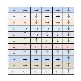
Flow direction diagram by the watershed tool
It is worth noting that when a sink is filled, other sinks may appear and then we have to do it again from the begging till all the wrong sinks obliterate. Subsequently, it is very useful to find the sink depth as it is the element which will help us find out if it is an error indeed or just a morphological feature. Below are the listed next steps.
- We create a raster layer with all the sinks and their depth, using the sink tool.
- With the contribution of the watershed tool, we create a raster file of the area for each sink, using the flow direction from the elevation raster and the output from the Sink tool as input for pour points.
- Pour points are the lowest points where water drainage flows out of the drainage basin.
At that point, the aid of a mathematics program for geographic analysis is important as we need to create another raster file with the minimum elevation of each sink which is going to be used on the GIS platform in further steps.
- Zonal fill tool helps us make a raster with the lowest elevation of the watershed which is the point where water drainage leaves the basin.
- In the end, we subtract the minimum from the maximum value to find the depth with the minus tool.
To conclude Digital Elevation Models from GIS are the most convenient and useful models to represent earth‘s surface as well as hydrology parameters flows, streams, pipelines, water drainage etc. Having all the necessary data and following the above steps on GIS we can complete a general study on the field of water drainage. Of course, every area is different and we cannot follow a standard guide for each case, however, the basic steps and tools were presented above. For further information and questions about GIS or water drainage, you can call at +49-30-20679116, or visit the site of Umwelt Informationstechnology Zentrum

