Land Use Mapping: A tool for land policy makers

GIS Business Applications
January 8, 2016
GIS based mapping for Agricultural Suitability Assessment
March 20, 2016
Global population increase leads to the demand for more shelter and food, which has resulted in pressure on land for different uses such as urban buildings and infrastructure, agriculture, transportation, recreation, etc. The pressure on land use has led to the transformation of land landscapes from one use to another which also affects the natural and human environments resulting in unsustainable development. Factors such as technological capacity, social relations, demand etc. affect environmental capacity and have great impacts on land-use change. Land use and its management have impacts on water, soil, plants and animals etc. as natural resources. To understand the impact of human settlements and resource development across the globe is to assess the condition and trend of land use resources. The issues related to land degradation, water quality etc. as natural resource management problems, the solutions to such problems can be derived from land use information. For effective policy and decision making on sustainable land use development, there is need for geo-visualization of land use pattern in relation to its spatial scales, hence map as a communication and geo-visualization tool has become a tool for land use analysis. Land use mapping is used to display or geo-visualise the pattern and the use to which land resources are put and it provides useful information on landscape characteristics for good policy-making on land management practices.
Technologies for land use mapping
Traditionally, maps are produced cartographically and remain as Cartographic products hence; Cartography has been the art, science and technology for map production. Ever since the fields of Geography and other earth’s sciences welcomed computer revolution for handling the vast amount of geographic data, mapping has been developed into advanced sophisticated technologies which include Geographical Information System (GIS), Remote Sensing (RS), Global Positioning System (GPS), etc. These mapping technologies are combined in most cases for land use mapping and for proper handling of geographical information for policymaking on sustainable land use development and management.
Land use data acquisition tool
Land use mapping requires land-use data in form of geographically referenced data i.e. data related to space and location. Due to the complexity of the real world where such data are to be collected, together with the spatial scale of land uses that are to be represented cartographically, sophisticated tools such as Remote Sensing and Global Positioning System have been applicable for land use data collection and these technologies have reduced challenges in geo-data collection for land use mapping. Remote Sensing, which is the art, science and technology for acquiring geographic data from a distance without having physical contacts with the geographic environments, is applicable in land use mapping in two ways: Photographic Remote Sensing that produces aerial photographs of land use and Non-photographic Remote Sensing that produces satellite images of land use. Global Positioning System, on the other hand, plays an important role in geo-data collection for land use mapping as it is used to acquire data such as the coordinate systems for the geo-referencing of the land use mapping. Remote Sensing and Global Positioning System are the major sources of data for land use mapping.
Land Use Data analysis tool
The issue of land use mapping does not stop at the data acquisition even if such land uses can be displayed and visualised on Remote Sensing satellite images and aerial photographs. This is because the policymakers may not be able to interpret and analyse the land use features on such images and photographs. To communicate useful information to policymakers, there is a need for proper handling of information from different sources through capturing, storing, retrieving, analysing displaying in such a way for the policymakers to understand and communicate. In order to achieve this goal, the Geographic Information System is applicable for effective geo-data analysis of land use data for land use mapping. GIS has the capability to classify different land uses of the same area, calculate the extent of land-use change, project future land-use change and display such analysis as geographically referenced information (map) in order to have a clear geo-visualisation of land use by the policymakers.
Problems in land use mapping
Problems related to spatial scale and data are associated with land use mapping. Most ground-based data covers few regions of the earth making spatial boundaries of some regions to lack or have insufficient data. Some remote sensing data that cover the earth may have the problems of data resolution to display the intensity of land use. However, there are Satellite Remote Sensing that has been able to acquire land use data with a very high resolution and high intensity of land use/cover. The issue of data gap especially in the developing world as the rate of land-use change increases is another challenge facing land use mapping. Some existing datasets are inconsistence due to some factors such as changes in data processing methods, survey, space such as boundaries, etc. Low technical known-how of some Cartographers and other map making professionals in relation to the application of some sophisticated mapping tools such as GIS, GPS and RS has great impacts on data for land use mapping. When such or similar problems occur during land use mapping, the land use information that will be communicated to policymakers may be inaccurate and this has negative impacts on policy and decision making on land use development and management.
Chhabdi land use mapping – a case study
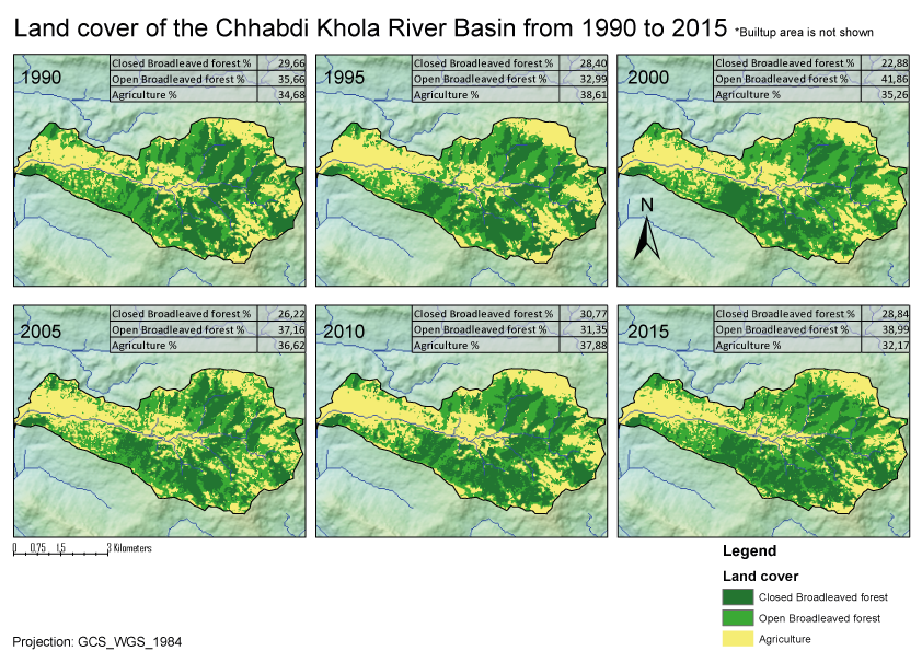 Geographically, Tanahun in Nepal lies between 83°57’15,104″E 28°5’24,774″N and 84°28’11,431″E 27°45’40,989″N. Chhabdi Khola land use in the eastern part of Tanahun was analysed. Most of the study areas are located near a city/village. The outlet of the Chhabdi Khola river basin is located at the east border of the city Damauli. The land cover was classified from 1990 to 2015, with intervals of 5 years.
There seems to be very little correlation between the progression of years and the share of agricultural area, which makes it difficult to assess whether the agricultural area is actually improving over a longer time period. Nevertheless, the share of the agricultural area is at its lowest in 2015 (compared to the other 5 year intervals), although this is no evidence that the agricultural area will also decrease in the future. Finally, there could also be less erosion as a result of the decrease in bare, agricultural areas (especially at steep slopes). This is also applicable to the other study areas.
Benefits of land use mapping for policy makers
Land use mapping benefit to policy makers as it provides useful and timely information related to land use and land cover change that will be used for sustainable development and management of land resources. Land use mapping helps the policy makers to assess the suitability of the use of land in relation to its capability such as climate, soil, slope, water, etc. problems. Furthermore, it helps policy makers to carry out environmental impacts assessment of land use which may lead to land degradation such as flood, drought, etc. in relation to agricultural productivity, land use mapping helps policy makers to assess agricultural productivity and opportunities in relation to land suitability. Nevertheless, land use mapping helps to facilitate natural resource condition and trend reports at the local, regional, and national levels which have also facilitated consistency policy making for sustainable land use development and management.
Services for Land use mapping and Policy Advisory
UIZ offers services for land use mapping for policy makers like:
- Land-use mapping and assessment of the suitability of land use in relation to its capability;
- Environmental impact assessment of land use that may cause degradation;
- Updating land use maps with the use of RS, GIS and GPS techniques;
- Projection of future land use and cover change for better decision-making at the policy, plan and programme levels.
For more information, please contact us at Tel: +49-30-20679113 and Email: [email protected].

