What is Web GIS and WebGIS Application

Use of GIS in Social Mapping Projects
November 24, 2016
Photogrammetry and Remote Sensing with GIS
September 5, 2017
Web GIS
After getting a lot of “What is Web GIS?” questions on our website despite having all the available online articles, I and my working colleague decided to explain Web GIS in basic terminologies as well as when it could be useful for you in this article and hopefully helps.
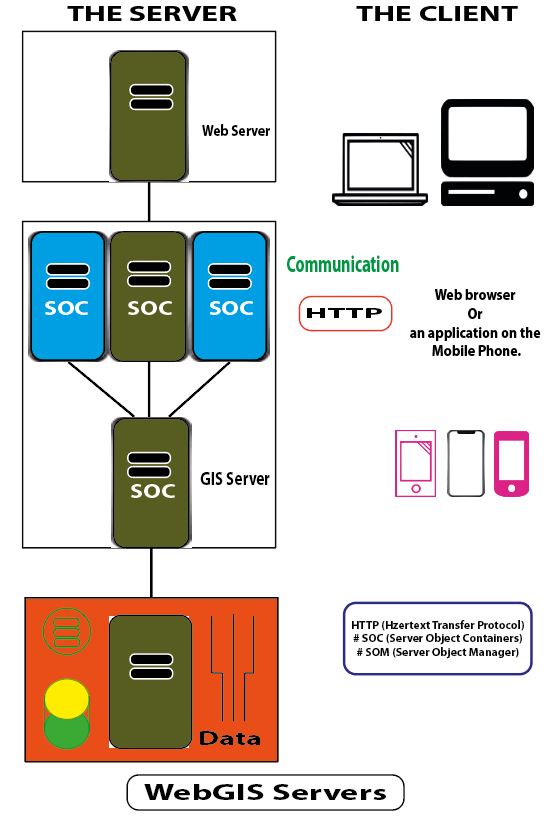
Web GIS as known to stand for “Geographical Information Systems” could be a little too technical, in simple terms can be summarized to mean a type of distributed information system which came to take over the traditional short-distanced desktop GIS. The essential components it comprises are “the server” and “the client” where the server is the GIS server and the client being web browser or even an application on the mobile phone. Therefore, it’s a way of enabling communication between the server and the client.
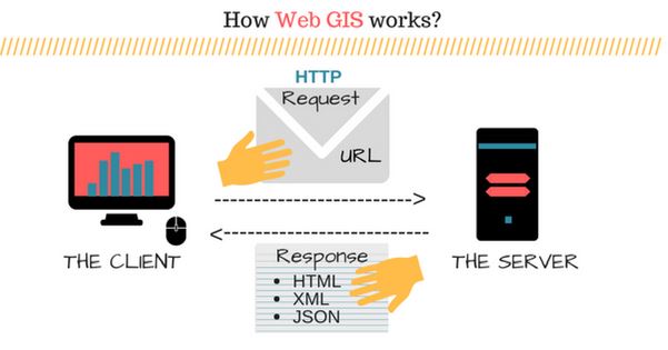
Here is how Web GIS works over a connection:
- The client reaches the server through a URL which is specific to the server concerned
- Requests from the clients to the server are sent relying on the HTTP (Hypertext Transfer Protocol) standardization
- The server then responds to the requests and send them back through HTTP
i.e. The various formats the response from the server could be in are HTML (Hypertext Mark-up Language); the common form, XML (Extensible Mark-up Language), binary image or JSON (JavaScript Object Notation).
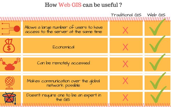
Now, let us turn to the main part of the article and see how Web GIS can be useful;
1. WebGIS allows a large number of users
When you have a large connection on clients then WebGIS would be the right way to go for communication as it allows a large number of users from anywhere to have access to the server all at the same time. The number of clients accessible spontaneously depends on how high the performance is as well as its scalability unlike the traditional desktop GIS where only one person is allowed at a time. The higher the performance, the higher the accessibility limit spontaneously.
2. Web GIS can be useful when limited in budget
Screening at the relativity between the number of users and the budget required shows that the budget in installing Web GIS is not as high as traditional desktop GIS. This can be seen through the accessibility of content from the internet. It is similar for Web GIS where one doesn’t have to pay to have access to Web GIS except for the provider who also still minimizes cost through Web GIS as they are installing only one system and avoid getting every client their PCs. So very useful for a large number of clients, remotely accessed, but also a very economical way of communication across.
3. Web GIS is useful if the network is over the Globe
HTTP is very trusted and allowed in almost every network in the world, therefore all organization open their firewalls to accept requests and send responses through local networks. This is of a big advantage as the nature of Web GIS is from HTTP, meaning Web GIS can be used to introduce applications accessible in PCs or mobile phones in almost everywhere in the world. Therefore, this will make communication over the global network possible.
4. Web GIS is ideal when the network has background-diverted clients
One of the very good properties of Web GIS is that it is easy to use and doesn’t require one to be a professional or an expert in GIS as in desktop GIS where it was intended for professional users only. Web GIS is as easy as using a normal website as it is mainly designed to improve usage simplicity, usage coverage and convenience. This had been a success making Web GIS much easier network communicating facilitator.
Web GIS is very useful and very widely used especially for mobile applications from maps, locators, tagging personal photos, displaying Wi-Fi hotspots, linking information and database between branches of the same company across long-distance and many more ways. If you think you need Web GIS developer, UIZ has a team of experienced experts dedicated to providing quality services to its clients. Feel free to reach us at +49-30-20679114 or visit our website at https://uizentrum.de/en/gis-services/webgis/


