GIS-Data Capture
GIS data capture is a technique in which the information on various map attributes, facilities, assets, and organizational data are collected, digitized and organized on a target GIS system with the appropriate layers.
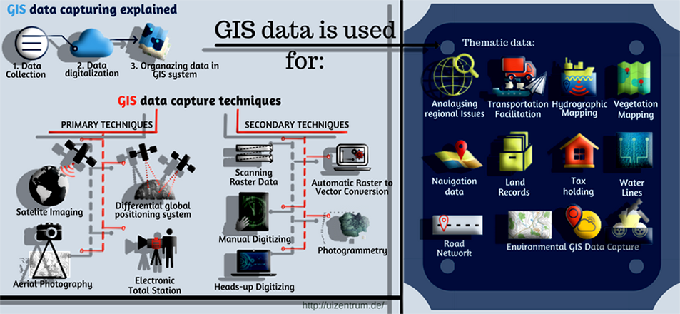
Our GIS Data Capturing Methods
Our primary data capture techniques which mainly use remote sensing and surveying techniques are:
- Raster Data Capture: Capturing of attributes without physical contact. This is usually done with the help of satellite imaging techniques and aerial photography. The advantage of this GIS data capture method is that there is a consistency in the data generated and the whole process can be regularly and systematically organized to get the most accurate data in a very cost effective manner.
- Vector Data Capture: Capturing of data-sets through physical surveying techniques such as Differential Global Positioning System (DGPS) and Electronic Total Station (ETS). Although this technique is the most effective process in order to obtain accurate results on the target GIS system, it is more time consuming and costly.
Our secondary data capture techniques include:
- Scanning Raster Data: High resolution scanners give very accurate raster images from the hard copies, which then can be georeferenced and digitized to get the vector output.
- Manual Digitizing: Digitization is done directly over the raster by the use of a digitizing tablet.
- Heads-up Digitizing: The raster scanned data is imported and laid below the vector data to be traced on the computer screen itself.
- Automatic Raster to Vector Conversion: UIZ uses special software with intelligent algorithms to recognize the patterns of the points, lines and polygon features and capture them automatically to generate vector GIS data.
- Photogrammetry: UIZ uses digital stereo-plotters to capture the vector data from the aerial photographs. This is comparatively the most effective method for accurately capturing GIS data.
GIS Data Capture Methods Used in Various Fields
- Thematic data is used for analysing regional issues, transportation facilitation, hydrographic mapping, vegetation and other types of related features.
- Navigation data is captured and used for easy navigation purposes.
- Land records and survey data are captured for property, land, water and holding tax, etc.
- Utility infrastructure GIS data capture for water lines, road network, pavements, sewerage network, and other related features.
- Environmental GIS Data capture is done from geological maps, weather maps, mining and mineral exploration maps, etc.
This page is also available in:

