WebGIS portal development and implementation

Data preparation and modeling according to the country land use policies
September 10, 2020
Installation, configuration, and upgrade of ERDAS APOLLO server
September 10, 2020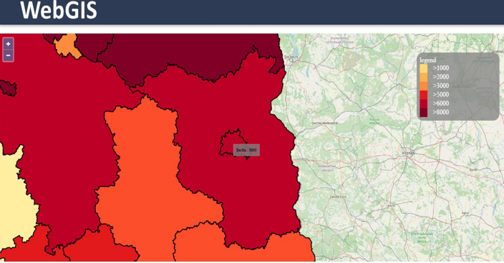
A WebGIS platform for land use data dissemination combines the knowledge of complex GIS systems
with the standards and best practices of information technology to design and implement an end-toend system that deliver land use data services, tools and applications on the Web. This article aims to
describe the WebGIS portal development and implementation for the development of a WebGIS
platform-based land use data dissemination system.
WebGIS portal development and implementation
For the WebGIS platform development process, is essential to create a WebGIS portal accessible for
stakeholders and the public. Moreover, it is required to host the system and to provide IT support
along the process.
a) Key Inputs/Data
i. ASP.NET programming, associated web scripting languages and technologies.
ii. ERDAS APOLLO server, Windows server 64-bit OS.
iii. ERDAS APOLLO engine.
iv. Data management tools.
b) Scope
i. To design and develop a Web interface for the WebGIS portal.
ii. To maintain data integrity between several layers.
iii. To provide a Web interface with multiple options to choose from the toolbar window.
iv. To integrate satellite imageries support in the system.
v. To mask the data and records of restricted or sensitive information from end users.
vi. To publish existing A1 and A4 maps.
vii. To publish the developed system in the Web interface that can be accessed through browser
using internet.
viii. To provide a Web space required to store large amount of spatial and non-spatial data by the
consultants.
xi. To provide domain and host management by the consultants.
c) Method
A WebGIS portal requires to be designed and developed comprehensively in supporting multiple
protocols. Moreover, it is crucial to developed a solution based on ASP.NET with Web scripting
languages and technologies such as Javascript, PHP, Silverlight, FLEX, AJAX, jQuery, SOAP, REST,
XML, JSON, etc. together with spatial RDBMSs, especially PostgreSQL/PostGIS and Microsoft SQL
Server. The solution will have ECWP/JPIP along with OGC Web services like WMS, WFS, WCS,
WFS-T, WMTS associated in one package. The developed solution will have an updating features
and vector data through OGC WFS-T interface.
There are three layers shows the services framework of how data need to be manipulated through the
Application Programming Interface (API):
i. OGC Web services interfaces.
ii. ERDAS APOLLO engine.
iii. Data connectors.
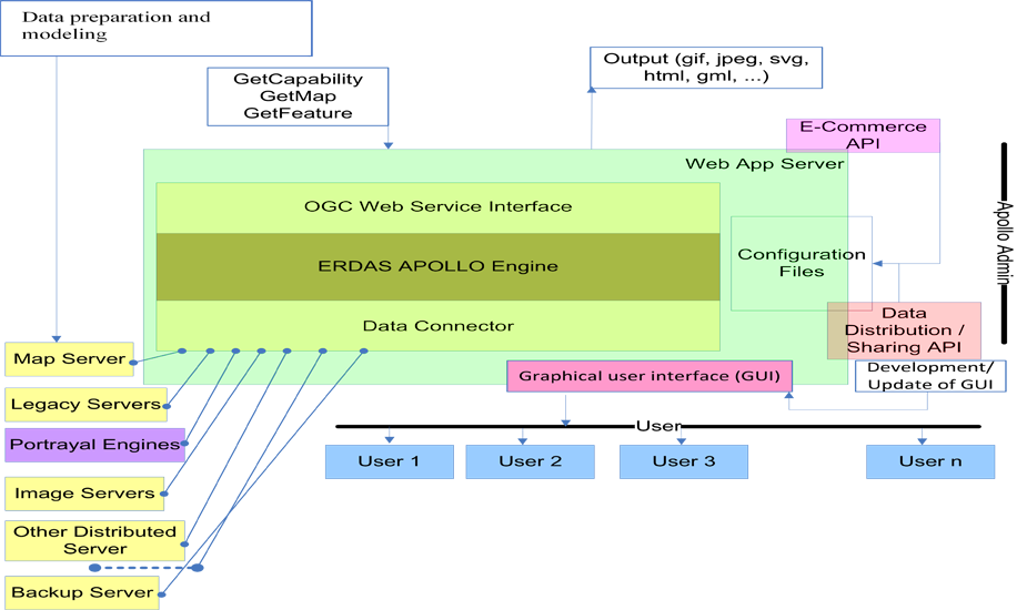
The following framework components need to be available within the WebGIS platform.
i. Scalable J2EE components.
ERDAS APOLLO server components required to be configured to make stable, scalable, and
reentrant with no risk of interference.
ii. ERDAS APOLLO Servlets.
It is essential to configure the ERDAS APOLLO Servlets for data management, conversion and map
projections. The system will support a high number of EPSG codes. Users can also convert from one
projection to another using EPSG code. Moreover, user with administrative rights can add a custom
EPSG code.
iii. Connectors and providers.
Maps of the project area including LRMP maps and database, and other associated documents as
specified by the client are required to be configured through specific connectors to access in an easy
way to the Web Service.
iv. Databases, flat files and imagery.
The data source can be LRMP maps, database, imageries and other associated data in various formats
e.g. an SQL database engine, another geo-engine, a data file, a raster image or coverage. This function
will allow multiples Web services to access the data. Each type of data source needs to be configured
with a specific connector having its own parameters that best match the internal connector model with
the Web service's one in the most suitable manner. ERDAS APOLLO solution toolkit is required to
be used to develop custom coverage data and metadata decoders.
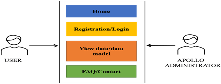
Anyone can use cataloging service to search the data. However, a user will have to register to obtain
login credential to view and order data. FAQ and contact modules are required to be integrated to
assist user for easy communication
After successfully completing the design and development phase, it is crucial to connect the WebGIS
platform GUI to ERDAS APOLLO server with the purpose of having an integrated module working
properly.
e) Requirements
• ERDAS APOLLO server, Windows server 64-bit OS.
• ERDAS APOLLO engine.
• Data management tools.
• Server machine and networking devices.
f) Results
Full functioning WebGIS platform-based land use data dissemination system.
If you want to learn more about the development of a WebGIS-based land use system, we invite you
to read our previous article and our upcoming article in
its process workflow.
The “Umwelt und Informationstechnologie Zentrum” UIZ has many years of experience in the
development of WebGIS software. For more information or other services, please contact us.
Umwelt und Informationstechnologie Zentrum, UIZ GmbH Address: Karl-Liebknecht-Str. 34, 10178 Berlin
Phone: +49-30-20679115
E-mail: info@uizentrum.de
Web: www.uizentrum.de


