Environmental Monitoring, Analysis and Interactive Visualization – EMAIV
Analysis and Interactive Visualization – EMAIV
EMAIV is a UIZ product that serves as a WebGIS application for monitoring, analyzing and visualizing environmental data over the Internet. The framework of the EMAIV can be divided into three categories:
- 1. Monitoring System: aims to monitor disaster sites and get information on the environment.
- 2. Database: manages in-situ and real time monitoring data, field investigating data, real time user input data and base data.
- 3. Analysing and Warning System: analyses monitoring data, understand the deformation trend of the potential disasters and release disaster warning information.
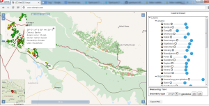
 Monitoring System
EMAIV is a GIS based software for monitoring environmental issues with a user-friendly interface. It is able to visualize environmental data such as water quality, geomorphologic data, ecological information, meteorologic and hydrologic data on maps. It then exports the map and performs the necessary operations, resulting in an efficient understanding of the data for better decision making.
 Data Management
The monitoring data coming from in-situ and real time collection is stored in the database as raw data for analysis and visualization. In addition to this, EMAIV allows the user to give information of any environmental issues that need urgent attention such as landslides, pollution, drainage breaks, waste, etc. These issues are then also stored in the database. Considering the information given by the user, quick fixes of the issues can be made by taking necessary measures to solve the problem.
 Analysis and Alert System
Data from sensors is passed directly into the analyzing and warning system, analyzing module, alerting module and monitoring module. The foundation of the analyzing and warning system is the analyzing module. The analyzing and warning system mainly aims to analyze real-time data and information monitoring of the potential disaster sites. Based on the given parameters and measured displacement, deformation trends are analyzed automatically by EMAIV. Finally, analyzing results (output data from EMAIV can be exported in required format) and warning information from the alerting module will be released to the public through the internet based on the monitoring module of EMAIV.
Features
- 1. Visualizing, analysis and real time reporting
- 2. Automatic quality assurance, alarms and control features
- 3. Sensors integration
- 4. User involvement by contributing data from the respective regions
- 5. Interactive results from monitoring and analysis
Advantages
- 1. Highly sensitive and reliable analytical data
- 2. Low maintenance cost
- 3. Extremely stable, with few calibration checks
- 4. Real time sensor data visualization
- 5. Web based analytical platform with interactive visualization
- 6. Less analytical calibration frequency
This page is also available in:

