Online data purchase mechanism preparation

Metadata harvesting and online cataloging system preparation
September 10, 2020
Support and maintenance: Land use data dissemination system
September 10, 2020
A WebGIS platform for land use data dissemination combines the knowledge of complex GIS systems
with the standards and best practices of information technology to design and implement an end-toend system that deliver land use data services, tools and applications on the Web. This article aims to
describe the preparation of online data purchase mechanism for the development of a WebGIS
solution-based land use data dissemination system.
Online data purchase Mechanism preparation
For the development of a WebGIS solution is essential to integrate the online data purchase
mechanism with the WebGIS server along with an ERDAS APOLLO server, to allow users to easily
order data of interest.
a) Key Inputs/Data
• Graphical user interface (GUI) for WebGIS.
The GUI allows users to interact with electronic devices through graphical icons and audio indicator
such as primary notation.
• Payment gateway.
A payment gateway will be provided by an e-commerce service that will authorize the payment
process by credit card or direct.
• Data Sharing API.
An Application Programming Interface is a software that allows the sharing of content and data
between programs in a structured and documented way.
b) Scope
• To develop options for area delineation and request for online map purchase requests.
• To integrate E-commerce features with customer support system.
• To integrate data sharing with sufficient data security mechanism.
c) Method
Online data purchase mechanism includes following steps:
i. E-Commerce API.
It is crucial that a Web based E-Commerce API is developed and integrated with Clip-Zip-Ship
functionality of ERDAS APOLLO server. System will provide options for area delineation either by
selecting AOI or by hierarchical administrative boundary as well as the data themes and request for
online map/data purchase request
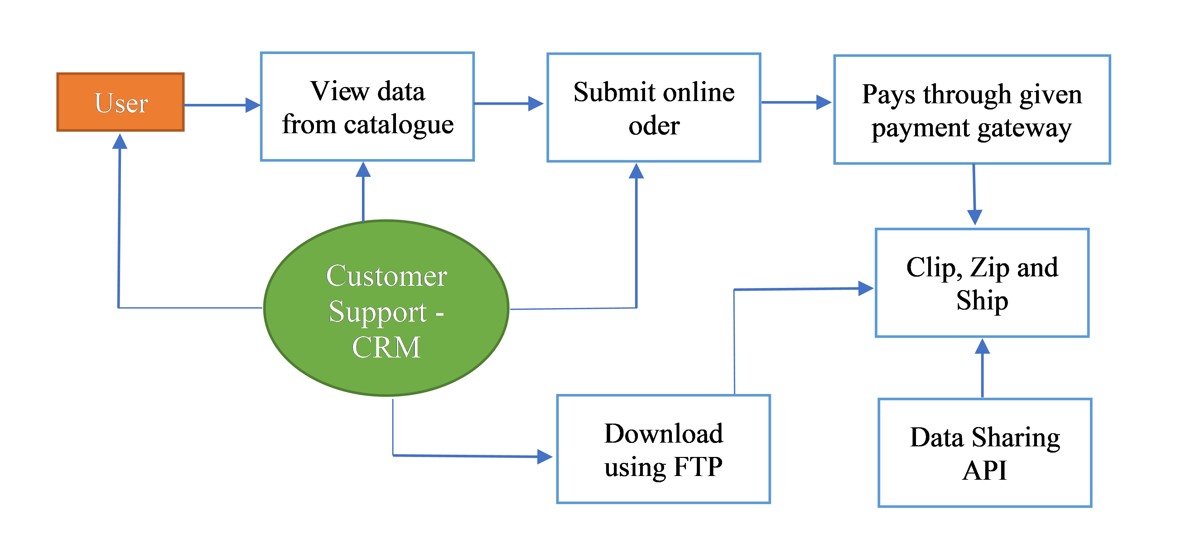
ii. Clip-Zip-Ship
Clip-Zip-Ship function requires to be configured in an ERDAS APOLLO geospatial portal to select
multiple coverages for download. In response to the download request, a ZIP file containing the
coverage requires to be created on the server. Then, an e-mail with the URL of the location of the ZIP
file will be sent to the user. The E-mail server requires to be configured for notifications.
Alternatively, ERDAS APOLLO Data Manager can be used for downloading purchased data with
same username as the username configured in FTP server.
iii. Data portrayal and delivery
ERMapper Algorithm files need to be configured for online image processing and support. The
solution will be able to perform complex raster process with stream high volumes of data over
Enhanced Compressed Wavelet (ECW) Protocol. The presented solution will perform with interactive
symbology over OGC compliant SLD both on server side as well as on client side along with Servlet
Components. The solution requires to be configured for features like dynamically portray imagery in
multiple ways, resolution merge, and band selection.
iv. Security
The solution entails to be configured in the way that administrator can set permissions and
restrictions. It is important that the Polygon masking feature is integrated for restricted regions.
Administrator will be able to configure spatial masking security and re-sampling resolution without
changing the actual data. Therefore, the same data is served differently to different users. The WebGIS
platform-based land use data dissemination system will utilize current state of the art security
protocols including Active Directory, LDAP, CAS, JASS, and LDAP etc. for user and data
management.
v. Processing
It is essential that the ERDAS APOLLO server is configured for retrieving data directly from the
Oracle Spatial and PostGreSQL9/PostGIS. The solution will have ‘On-The-Fly Reprojection’ and
‘On-The-Fly Mosaic’ functionalities along with complex raster processes capability.
vi. User access features
The system entails to be configured so that user can design an online map with map customization
functions. The following features need to be made available to the end users:
i. Provision for online map design, symbology changes etc.
ii. System provision of measurement in online map itself.
iii. Pop ops available on click online map.
iv. Provision of selecting AOI of the data for download.
v. Provision of preview of data and printing the data, based on
permissions.
vi. Sharing (Collaboration).
Based on login credential the user will be able to upload/download and update data
online. With Sharing API user can share data with their collaborators. Printing function will allow
user to print map/images in A1 and A4 size. We have descrived the process description of a WebGIS based land use data system.
If you want to learn more about the development of a WebGIS-based land use system, we invite you
to read our previous article and our upcoming article in
its process workflow.
The “Umwelt und Informationstechnologie Zentrum” UIZ has many years of experience in the
development of WebGIS software. For more information or other services, please contact us.
Umwelt und Informationstechnologie Zentrum, UIZ GmbH Address: Karl-Liebknecht-Str. 34, 10178 Berlin
Phone: +49-30-20679115
E-mail: info@uizentrum.de
Web: www.uizentrum.de


