What is Data Integration?
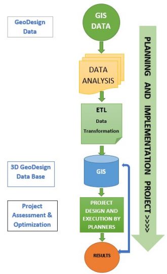
Data Integration is a very complex process that brings together all kinds of data from internal and external sources and providers and, with the help of technologies and techniques, offers a wide view over things in order to solve different challenges that companies may face. However, one must pay attention to each and every step that involves and answer some crucial questions in order to maximize the result. Some of the main questions that should be responded to are:
- What is the purpose of data integration?
- What is the expected result?
- Is the source or the provider of data trustworthy?
- What are the tools needed for processing the data?
- What is the necessary software?
- How much time will it take and what are the costs of collecting and processing the data? Is the data available?
- Are the data collections complete?
- Have you decided what you want to use the data integration for?
- What about the money and time you are willing to invest in this?
If you have answers to these questions, you may let them rest in our hands. UIZ is a company that has the software, tools and very-well-trained staff that can provide you with the solution to your problem. The software and servers that we use for data integration: QGIS, GrassGIS, PostgreSQL, Geoserver, Leaflet, etc.

What are the tools needed to complete the Data Integration?
The tools are used to ease and shorten the time of processing data.Depending on the purpose of data integration, here is a list of tools that might be required to get to the intended result:
- Measure : Distances, areas and volumes ( data which is exportable in different formats (CSV, JSON, XLM).
- Measurement lines: point to point, orthogonal.
- Drawing function ( lines, areas, text, symbols).
- Export/ Import of data in different formats .
- The buffer tool - has proximity functions.
- The clip tool - it helps you to clip a certain area you want to focus on .
- The merge tool - combine 2 or more layers or datasets.
- The dissolve tool - unifies boundaries based on common attribute values
- The eraser tool - Erase lines, points, areas.
- The intersect tool - the difference between this one and clip tool is that the intersect tool preserve all the attributes from all the datasets that overlap in the resulted model.
- The union tool - keeps all input features attributes and boundaries in the output feature class .
What are the techniques that we use?
- Manual Integration - collecting and processing of data is made individually from each source, so there is no unified view.
- Application Based Integration - We use a range of applications to integrate the data.
- Middleware Data Integration - the transition of data integration logic from particular applications to the middleware layer.
- Virtual Integration -leaves data in the source systems and defines a set of views to provide and access the unified view to you across the whole enterprise.
- Physical Data Integration -We create a new system, but keep a copy of the data from the original system, to store and manage it independently of the source system.
We will also test the applications and maps that we create for you, just to make sure that you get what you expected.
But guess what? You don’t have to worry about the security of the data. Leave that on us!
Are you still wondering what are the benefits of data integration?
Here are some benefits that could make you take the right decision:
- Security and integrity of the data.
- Multiple trustworthy sources and providers brought together.
- A filtered set of metadata displayed in a single view.
- Increased Competitiveness.
- Better understanding of the available solutions.
- Up-to-data data are available.
Get in touch with us!
If you think that we are what you are looking for, don’t hesitate to contact us! We will make sure that you will get the maximum support in the challenge you are facing, from the best professional team!

