Data preparation and modeling according to the country land use policies

Development of a WebGIS platform-based land use data dissemination system
September 9, 2020
WebGIS portal development and implementation
September 10, 2020
A WebGIS platform combines the knowledge of complex GIS systems with the standards and best
practices of information technology to design and implement an end-to-end system that delivers land
use data services, tools and applications on the Web. This article aims to describe the data preparation
and modeling according to the country land use policies of the WebGIS software-based land use data
dissemination system development.
Data preparation and modeling according to the country land use policies.
In the process of developing a WebGIS software it is necessary to prepare and harmonize GIS maps
and GIS databases. Moreover, the modeling is required to be according to the land use policies for
disseminating land resource maps and information. All this through a WebGIS platform accessible to
stakeholders and the public.
Detailed requirements, scope and method are thematically categorized as follows:
a) Key input/data
The following data is be vital for preparation of spatial and non-spatial data to be published on the
WebGIS software.
i. Present land use maps, database and reports.
ii. Soil maps, database, and reports.
iii. Land capability maps, database and reports.
iv. Land use zoning maps, database and reports.
v. Parcel superimpose maps, geodatabase and reports.
vi. Infographics and relevant data and reports.
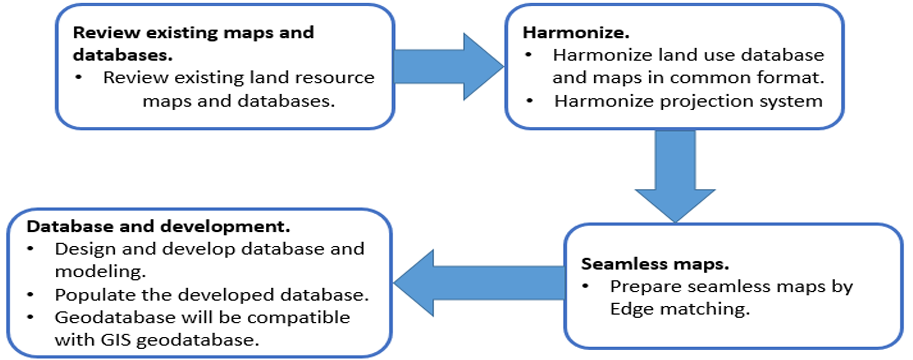
b) Scope
i. To harmonize GIS maps and GIS database in a common format.
ii. To harmonize the projection system of all the relevant GIS maps and GIS database.
iii. To prepare seamless GIS maps of the project area.
iv. To design and develop a geodatabase which must be compatible with a GIS geodatabase.
c) Method
The entire GIS database, GIS maps and reports needs to be reviewed. Furthermore, each database and
maps need to be harmonized to bring them into a common format. Moreover, the GIS database and
GIS maps are required to be converted to a common projection system as requested by the client.
Additionally, seamless maps need to be produced by edge matching technique. Finally, Geodatabase
is required to be designed and to be compatible with ESRI’s Personal/File Geodatabase.
d) Requirements
i. GIS Software.
A geographic information system (GIS) allows working with geographic data and maps. This
system is manly used for creating maps, analyzing data in a map, using geographic
information in a variety of applications, and managing geographic information in a database.
ii. Relational Database Managements System RDBMS.
A RDBMS is a digital database that stores data using rows and columns and is based on the
relational model of data. The values within the database are related and making possible to
run queries throughout tables.
i. Computer.
To install and run the software, the WebGIS platform needs hardware components to be
present on a computer.
e) Results
ii. Harmonized land resource database and maps (both in style, attribute and projection
system).
iii. Geodatabase compatible to GIS geodatabase.
Providing you the process description of the data preparation and modeling
according to the country land-use policies for the WebGIS platform-based land use data dissemination
system development.
If you want to learn more about the process workflow to develop a WebGIS-based land use
dissemination system, we invite you to read our next article.
The “Umwelt und Informationstechnologie Zentrum” UIZ has many years of experience in the
development of WebGIS software. For more information or other services, please contact us.
Umwelt und Informationstechnologie Zentrum, UIZ GmbH Address: Karl-Liebknecht-Str. 34, 10178 Berlin
Phone: +49-30-20679115
E-mail: info@uizentrum.de
Web: www.uizentrum.de


