Types of Geodata Storing in GIS

Watershed Monitoring by GIS
May 8, 2018
Geospatial Intelligence and the GIS
May 10, 2018
About Geodata
Geographic data or more briefly geodata is the information referred to spatial objects, features of a specific location, or other general data which are related to the location they belong. Geodata could be everything, for example, data about wars in the past, could be visualized according to the locations where they took place and in that way to be considered as geodata, even though wars are not primary geographic data.
There is a big variety of examples, but to make the long story short, what we have to understand is that any data which can be associated with geography, location, and spatial data, automatically is transformed into geodata. This process led us to the need for better management of geodata, therefore better storing according to the nature of the geodata and what we want to do with them. So below we will see what choices we have when we want to store our geodata and which is the proper method depending on the different applications.
Simple data related to the corresponding location, becoming geodata.
Geodata storing in Geodatabase
The geodatabase is the most common way for storing, querying and managing geodata. Consisted of many geographic datasets in one file which can be elaborated either from one person or from a whole company. Geodatabases can have many sizes depending always on the scope and the reason for geodata existence. It constitutes the natural data structure of GIS for every kind of process we want to do. Even though there are many file formats for geodata, the geodatabase allows us to take advantage of all its capabilities in managing and editing geodata. Moreover, geodatabases can be used, edited and have access to them through a Database Management System (DBMS) using SQL or the simplest way with GIS system.
Tabular geodata storing
Another option of storing and editing geodata is through tabular forms such as databases from other software, spreadsheets from Excel, dBASE tables, attribute tables etc. This option gives us the ability to receive geodata from many sources and to have a spherical view of the field of study. However, some of these sources are not suitable for editing geodata but only for reading, such as text formats of Microsoft, ASCII, data sources accessed through OLE DB etc. On the other hand, GIS system provides many advanced extensions of tabular data which gives us the opportunity for total editing and management not only for the geodata but for the whole tabular file. These extensions are ArcSDE, attribute table, dBASE, and others.
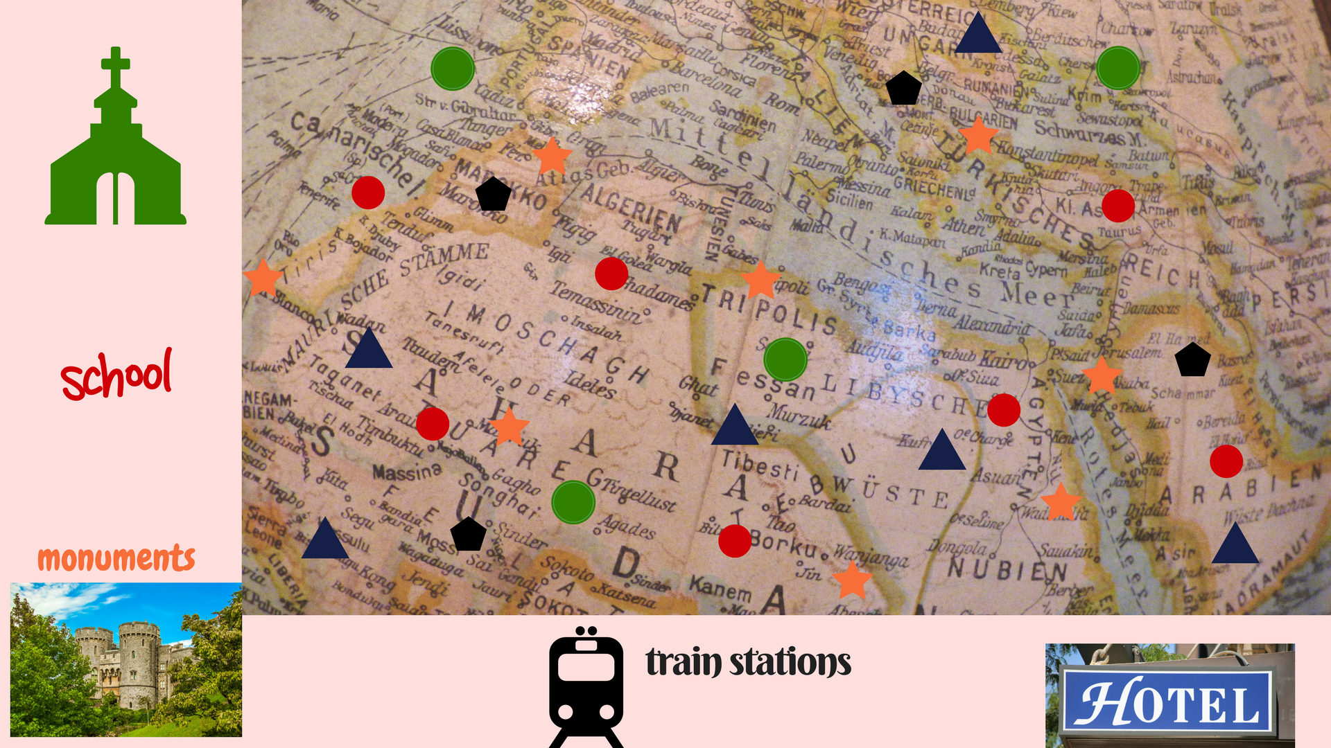
Shapefiles for geodata storing
A shapefile is a file including digitized geometric features existing on a map conforming to their actual position on the earth. Shapefile recognizes features in point, line and polygon form. Behind those features, we can create a corresponding attribute table with further information about the digitized items and this process founds another way of geodata storing. Multi-layering all the shapefiles we have of the same area we can take as a result a map that will relate data with the location. Extremely useful also for text data which can be correlated to several features and shown on the map.
Geodata storing and raster image
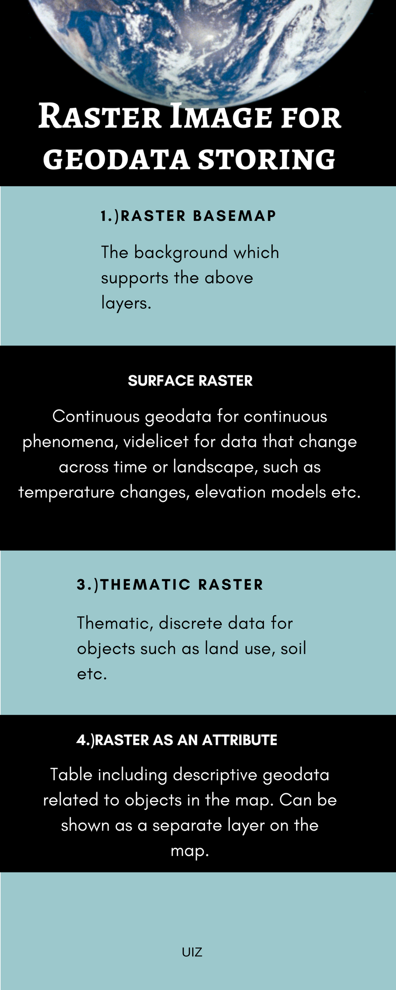
Raster images consist of a matrix of cells where each of them has a value which represents geodata. It is possible sometimes our geodata to be stored directly as a raster image (for example digital aerial photographs, satellite images, scanned maps etc.) without having the possibility to save it in the format we want, however, raster images have many advantages too. Let’s see some of them:
-
Each cell of a raster image represents a coordinate on the earth and has a corresponding attribute table with features which belong in this coordinate. This means many data and information organized and easy to manage.
-
The ability for innovative spatial and statistical analysis.
-
Convenience in representing surfaces with continuous geodata, but also to store and edit points, lines, and polygons.
-
Quick management of complex datasets as well as over-layering for better representation and editing.
However, there are also some disadvantages for geodata storing as a raster image, such as spatial inexactness happening because of the big cell size, occupation of big storage space on the disk and low quality of resolution depending on the cell dimension.
Geodata storing with coverage
Coverage is a storing model mainly for vector geodata while it may include spatial and descriptive data also. It has the form of a directory where each digitized or classified feature is saved as a set of files, including other subfolders. Moreover, the size of the coverage depends on the classes of the items which are usually many to describe well enough the objects of the map.
Geodata gives us many opportunities for storing, depending on what we want to do with them. However, the options are decreasing when our geodata is an only vector or only raster. When we want to manage them from the beginning until the end, or when we only want to read them. But even if the choices are decreasing, we will always have a way to store geodata properly.
UIZ, an expert in every kind of geodata storing is here to undertake even the hardest project and implement it through GIS. For more information call us at +49-30-20679130 or visit out UIZ webpage.


