Project Description
Client
 HVD - Humanistischer Verband Deutschlands - Berlin-Brandenburg
Date
 October, 2016
The client
Founded in 1993 in Berlin, the Humanistischer Verband Deutschlands (HVD) is an organisation
with the aim to encourage and disseminate a secular humanist worldview and an advocate
for the rights of people with no religion. About 20,000 people are members of this
organisation.
Requirements and challenges
Within the needs of HVD organization was the visualization of spatial data such as the location
of:
• Patients
• Volunteers
• Partner organizations
• The headquarter
• The intercultural Hospice Dong Ban-Ja.
The client need was to display spatial data in an organized and complete way.
The solution
UIZ in Berlin developed a WebGIS for data mapping and data visualization in which the spatial
data of HVD was displayed according to its preferences. This technic allowed the client to
visualize several layers on the map to avoid any confusion. Another advantage of the
application was the complete overview a user can get while displaying separate locations for
several data sets.
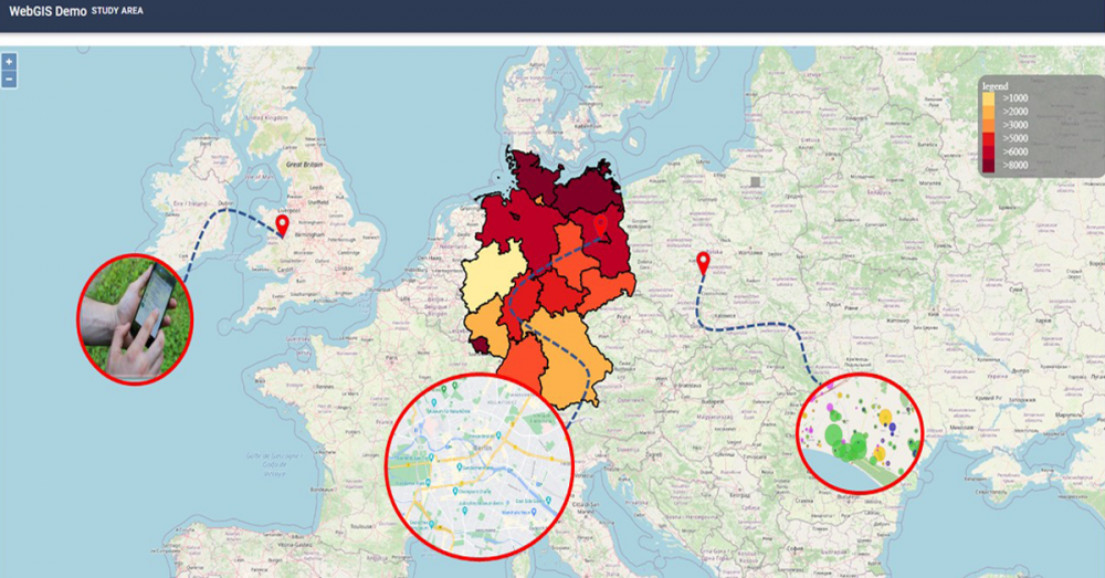
The result
The WebGIS for data mapping and data visualization developed for HVD showed interactive
maps with the patients, volunteers, partner organizations, the headquarter and the
intercultural Hospice Dong Ban-Ja. Within the WebGIS, the user could decide which content
he wants to show by clicking on the headlines on the interactive map. Also, the map allowed
the user to zoom in and to click on the relevant icon of interest.
The customer was really satisfied with our support services. The following tasks were
achieved.
• Collection of data for data mapping and data visualization.
• Process of data and background building in a database for notifications.
• Creation of an interactive map that includes information required for the project.
• Creation of the connection between the database and interactive map.
• Final map showing all the locations of the markers.
• The possibility to click on one of the markers and the notification will appear with the
related information.
With years of experience, professional and specialized staff, “Umwelt und Informationstechnologie
Zentrum” UIZ GmbH supports you in the development of a WebGIS adjustable to the needs of your
project.
For more information or other services, please contact us.
Umwelt und Informationstechnologie Zentrum, UIZ GmbH Address: Karl-Liebknecht-Str. 34, 10178 Berlin
Phone: +49-30-20679115
E-mail: info@uizentrum.de
Web: www.uizentrum.de